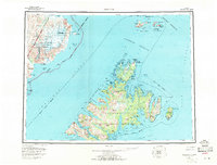
USGS Topo Quad Afognak, Alaska
Download Afognak
Download Afognak
Southern Latitude:
58.0000 N
Eastern Longitude:
-151.5000
Northen Latitude:
59.0000 N
Western Longitude:
-154.0000
Abandoned Towns(s) in Afognak
Kaguyak,
Archipelago(s) in Afognak
Shakun Islets,
Bar(s) in Afognak
Big Rock,
Danger Reef,
Douglas Reef,
Latax Rocks,
Skipwith Reefs,
Starr Rocks,
Village Reefs,
Bay(s) in Afognak
Port William,
Afognak Bay,
Amatuli Cove,
Andreon Bay,
Back Bay,
Back Bay,
Big Bay,
Big Waterfall Bay,
Bluefox Bay,
Carry Inlet,
Cook Inlet,
Daylight Harbor,
Delphin Bay,
Devil Inlet,
Devils Bay,
Discoverer Bay,
Driver Bay,
Duck Bay,
Esther Lagoon,
Foul Bay,
Izhut Bay,
Kazakof Bay,
King Cove,
Kitoi Bay,
Port Lawrence,
Little Waterfall Bay,
Malina Bay,
Malka Bay,
Marka Bay,
Marmot Bay,
Mary Anderson Bay,
Muskomee Bay,
Neketa Bay,
Onion Bay,
Paramanof Bay,
Pauls Bay,
Perenosa Bay,
Phoenix Bay,
Pinnacle Rock,
Redfox Bay,
Saposa Bay,
Seal Bay,
Selezen Bay,
Selief Bay,
Shangin Bay,
Shuyak Harbor,
Sukoi Bay,
Swikshak Bay,
Swikshak Lagoon,
Tidal Basin,
Tonki Bay,
Waskanareska Bay,
Western Inlet,
Wonder Bay,
Yukuk Bay,
Cape(s) in Afognak
Point Banks,
Bare Point,
Black Cape,
Bukti Point,
Cape Chiniak,
Cape Current,
Cape Douglas,
Cape Izhut,
Cape Kazakof,
Cape Kostromitinof,
Cape Newland,
Cape Nukshak,
Cape Nuniliak,
Cape Paramanof,
Cape Saint Hermogenes,
Carshan Point,
Delphin Point,
Dolphin Point,
Duck Cape,
Eagle Cape,
Graveyard Point,
Last Point,
Lighthouse Point,
Lipsett Point,
Malina Point,
Marmot Cape,
Otrubistoi Point,
Party Cape,
Peril Cape,
Pillar Cape,
Posliedni Point,
Posliedni Point,
Raspberry Cape,
Rivermouth Point,
Selezen Point,
Settlement Point,
Shields Point,
Steep Cape,
Tanaak Cape,
Tetrakof Point,
Tiger Cape,
Tolstoi Point,
Tonki Cape,
Tonki Cape Peninsula,
Ustia Point,
Channel(s) in Afognak
Big Fort Channel,
Cape Current Narrows,
Dark Passage,
Eastern Passage,
Marmot Strait,
Perevalnie Passage,
Raspberry Strait,
Shuyak Strait,
Skiff Passage,
Stevenson Entrance,
Dam(s) in Afognak
Big Kitoi Dam,
Port Wakefield Dam,
Port William Dam,
Glacier(s) in Afognak
Fourpeaked Glacier,
Spotted Glacier,
Island(s) in Afognak
Afognak Island,
Afognak Island,
Alexander Island,
Alligator Island,
Arnkil Island,
Ban Island,
Barren Islands,
Bear Island,
Big Fort Island,
Dark Island,
Delphin Island,
Discoverer Island,
Dot Island,
East Amatuli Island,
Ermine Island,
Grassy Island,
Green Island,
Gull Island,
Hog Island,
Hogg Island,
Kiukpalik Island,
Lamb Island,
Little Fort Island,
Marmot Island,
Midarm Island,
Ninagiak Island,
Nord Island,
Nukshak Island,
Parrot Island,
Perevalnie Islands,
Raspberry Island,
Rocky Island,
Sea Otter Island,
Seal Islands,
Sealion Rocks,
Sentinel Rock,
Shag Island,
Shakun Rock,
Shangin Rock,
Shuyak Island,
Stripe Rock,
Sud Island,
Sugarloaf Island,
Teck Island,
Ushagat Island,
Vantage Rock,
West Amatuli Island,
Winter Island,
Lake(s) in Afognak
Lake A B Schwartz,
Afognak Lake,
Big Kitoi Lake,
Big Kitoi Lake,
Gretchen Lake,
Hidden Lake,
Laura Lake,
Little Kitoi Lake,
Lower Malina Lake,
Pauls Lake,
Portage Lake,
Upper Malina Lake,
Mountain(s) in Afognak
Afognak Mountain,
Cloud Peak,
Devilpaw Mountain,
Dome Peak,
Mount Douglas,
Duck Mountain,
Edge Mountain,
Fourpeaked Mountain,
Godfrey Mountain,
Hatchery Peak,
Katenai Hill,
Litnik Mountain,
Mount Lowell Wakefield,
Mount Martin,
Owen Mountain,
Paramanof Mountain,
Puffin Peak,
Red Peak,
Table Mountain,
Pillar(s) in Afognak
Laida Rocks,
River(s) in Afognak
Afognak River,
Big River,
Swikshak River,
Stream(s) in Afognak
Bear Creek,
Hatchery Creek,
Malina Creek,
Village(s) in Afognak
Afognak,
Aleneva,
Aleut Village,
Duck Village,
Port Wakefield,
Port William,