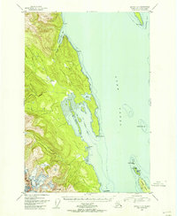
USGS Topo Quad Juneau C-4, Alaska
Download Juneau C-4
Download Juneau C-4
Southern Latitude:
58.5000 N
Eastern Longitude:
-135.0000
Northen Latitude:
58.7500 N
Western Longitude:
-135.3333
Bar(s) in Juneau C-4
Vanderbilt Reef,
Bay(s) in Juneau C-4
Boat Harbor,
Saint James Bay,
William Henry Bay,
Cape(s) in Juneau C-4
Point Saint Mary,
Point Whidbey,
Danger Point,
Lance Point,
Saint James Point,
Channel(s) in Juneau C-4
Lynn Canal,
Island(s) in Juneau C-4
Little Island,
Lynn Brothers,
Ralston Island,
Mine(s) in Juneau C-4
Alaska Endicott Mine,
Mountain(s) in Juneau C-4
Nun Mountain,
Park(s) in Juneau C-4
Saint James Bay State Marine Park,
River(s) in Juneau C-4
Beardslee River,
Stream(s) in Juneau C-4
William Henry Creek,