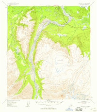
USGS Topo Quad Mount Hayes C-2, Alaska
Download Mount Hayes C-2
Download Mount Hayes C-2
Southern Latitude:
63.5000 N
Eastern Longitude:
-144.5000
Northen Latitude:
63.7500 N
Western Longitude:
-145.0000
Lake(s) in Mount Hayes C-2
Craig Lake,
Lisa Lake,
South Johnson Lake,
Mountain(s) in Mount Hayes C-2
Horn Mountain,
Ridge(s) in Mount Hayes C-2
Independent Ridge,
River(s) in Mount Hayes C-2
Johnson River,
Slough(s) in Mount Hayes C-2
Johnson Slough,
Stream(s) in Mount Hayes C-2
Dry Creek,
Elting Creek,
Pegmatite Creek,
Prospect Creek,
Sheep Creek,
Village(s) in Mount Hayes C-2
Dry Creek,