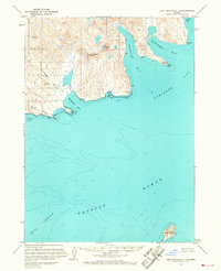
USGS Topo Quad Port Moller C-1, Alaska
Download Port Moller C-1
Download Port Moller C-1
Southern Latitude:
55.5000 N
Eastern Longitude:
-160.0000
Northen Latitude:
55.7500 N
Western Longitude:
-160.3333
Bay(s) in Port Moller C-1
American Bay,
Chichagof Bay,
Orzinski Bay,
West Cove,
Windbound Bay,
Cape(s) in Port Moller C-1
Blunt Point,
East Point,
Elephant Point,
Waterfall Point,
West Point,
Island(s) in Port Moller C-1
Karpa Island,
Mountain(s) in Port Moller C-1
Chichagof Peak,
Mount Stepo,
Stream(s) in Port Moller C-1
Susie Creek,
Valley(s) in Port Moller C-1
Chichagof Valley,